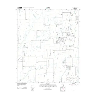
2013 Map of Celina
USGS Topo · Published 2013About this map
Celina serves as the central hub of this North Texas survey, exhibiting the grid patterns and expanding residential roads typical of the early 21st century. The landscape is defined by the drainages of Little Elm Creek, Mustang Creek, and Doe Branch, which weave through the agricultural and developing lands. For those tracing local heritage, the map identifies several historic burial grounds including Old Union Cemetery near the town center, Old Celina Cemetery to the southwest, and Crossroads Cemetery on the eastern edge. Local transportation and history intersect at the Old Preston Trail, while small-scale aviation is represented by Celina Field Airport and Cavanaugh Ranch Airport. To the south, the community of Parvin sits near the banks of Doe Branch, marking a distinct pocket of settlement away from the primary municipal center.
Find a feature on this map
136 named features on this map. Tap any name to fly to it.
Don’t see what you’re looking for? This feature index may not catch every label — zoom into the map to look around manually.
Map Details
Editions of this 2013 Celina Map
This is the sole edition of this map. No revisions or reprints were ever made.
Other maps of this area

1929 · Frisco
USGS Topo · 1:62,500

1929 · McKinney
USGS Topo · 1:62,500

1954 · Sherman
USGS Topo · 1:250,000

1958 · Sherman
USGS Topo · 1:250,000

1960 · Frisco
USGS Topo · 1:24,000

1960 · Celina
USGS Topo · 1:24,000

1960 · Aubrey
USGS Topo · 1:24,000
1960 · Little Elm
USGS Topo · 1:24,000
1960 · McKinney West
USGS Topo · 1:24,000

1961 · Gunter
USGS Topo · 1:24,000