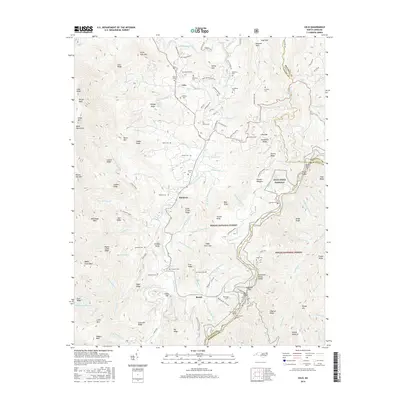
2016 Map of Celo
USGS Topo · Published 2016About this map
Celo and Busick anchor this survey of the high mountain reaches of Yancey and Mitchell Counties, where the South Toe River carves a central valley between the massif of the Black Mountains and Sevenmile Ridge. The landscape is defined by the high elevations of Percys Peak and the Celo Ridge, yet the map records a high density of small family-named cemeteries such as Gibbs Cem, Patton Cem, and Westall Cem, suggesting a long-standing pattern of kinship and settlement in the narrow coves. Transportation routes like the Blue Ridge Parkway wind through the southeastern portion, intersecting the Tennessee Valley Divide and passing landmarks like Buck Creek. The inclusion of Pollard Mine Rd and industrial features like Twin Tunnel North reflects the region's intersection of natural preservation within the Pisgah National Forest and the infrastructure required to traverse this complex terrain.
Find a feature on this map
156 named features on this map. Tap any name to fly to it.
Don’t see what you’re looking for? This feature index may not catch every label — zoom into the map to look around manually.
Map Details
Editions of this 2016 Celo Map
This is the sole edition of this map. No revisions or reprints were ever made.
Other maps of this area

1900 · Mount Mitchell
USGS Topo · 1:125,000

1902 · Mount Mitchell
USGS Topo · 1:125,000

1934 · Micaville
USGS Topo · 1:24,000

1934 · Spruce Pine
USGS Topo · 1:24,000

1934 · Parts Of Celo And Black Brothers
USGS Topo · 1:24,000

1934 · Parts Of Old Fort and Montreat
USGS Topo · 1:24,000

1935 · Montreat
USGS Topo · 1:24,000

1935 · Black Brothers
USGS Topo · 1:24,000

1935 · Burnsville
USGS Topo · 1:24,000
1939 · Burnsville
USGS Topo · 1:24,000