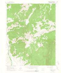
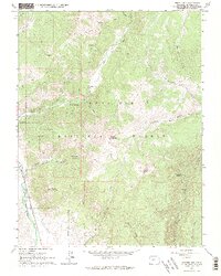
1961 Map of Cement Mountain
USGS Topo · Published 1964About this map
Gunnison National Forest dominates this high-altitude survey, where the valley floor of the East River gives way to steep drainages and peaks. In the early 1960s, this area served as a focal point for seasonal recreation and forest management, anchored by the Cement Summer Home Group and a nearby Guard Station along Cement Creek. A network of pack trails, including the Deadman Gulch Pack Trail, suggests a landscape accessible primarily by foot or horse, while a Railroad Grade along the river reflects the region's industrial past. The topography is defined by significant elevations such as Cement Mountain and East Cement Mountain, which overlook numerous gulches and basins like Horse Basin and Rosebud Gulch. Natural landmarks such as a Hot Spring and Point Lookout provide clear points of reference for those navigating this remote mountain terrain.
Find a feature on this map
30 named features on this map. Tap any name to fly to it.
Don’t see what you’re looking for? This feature index may not catch every label — zoom into the map to look around manually.
Map Details
Editions of this 1961 Cement Mountain Map
5 editions found
Other maps of this area

1888 · Crested Butte
USGS Topo · 1:62,500

1889 · Crested Butte
USGS Topo · 1:62,500

1893 · Crested Butte
USGS Topo · 1:62,500

1934 · Taylor Park
USGS Topo · 1:62,500

1937 · Taylor Park
USGS Topo · 1:62,500

1941 · Pitkin
USGS Topo · 1:62,500

1945 · Pitkin
USGS Topo · 1:62,500

1956 · Montrose
USGS Topo · 1:250,000

1959 · Montrose
USGS Topo · 1:250,000

1960 · Montrose
USGS Topo · 1:250,000