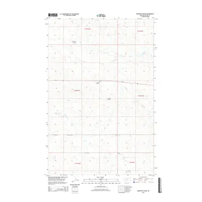
2014 Map of Cemetery Coulee
USGS Topo · Published 2014About this map
Haglunds Ritchie Cem sits at the center of this landscape in McCone County, illustrating the sparse but enduring presence of homestead-era history in eastern Montana. The map is defined by its namesake Cemetery Coulee and a network of ephemeral drainages including Soda Creek, Coal Cr, and Skull Creek. These waterways carve through the terrain, creating the distinct coulee formations typical of the region. Transportation is primarily limited to MT-200 and localized routes such as Skull Creek Rd and Green Trail Rd, which follow the natural contours of the land. The mapping of Wilbur Rd and various section lines provides essential context for family researchers and land historians interested in the township and range divisions of this rural landscape.
Find a feature on this map
17 named features on this map. Tap any name to fly to it.
Don’t see what you’re looking for? This feature index may not catch every label — zoom into the map to look around manually.
Map Details
Editions of this 2014 Cemetery Coulee Map
This is the sole edition of this map. No revisions or reprints were ever made.
Other maps of this area

1954 · Jordan
USGS Topo · 1:250,000

1954 · Glendive
USGS Topo · 1:250,000

1956 · Jordan
USGS Topo · 1:250,000

1957 · Glendive
USGS Topo · 1:250,000

1958 · Jordan
USGS Topo · 1:250,000

1958 · Glendive
USGS Topo · 1:250,000

1964 · Jordan
USGS Topo · 1:250,000

1965 · Hedstrom Lake
USGS Topo · 1:24,000

1965 · Hedstrom Lake NW
USGS Topo · 1:24,000
1965 · Berry School
USGS Topo · 1:24,000