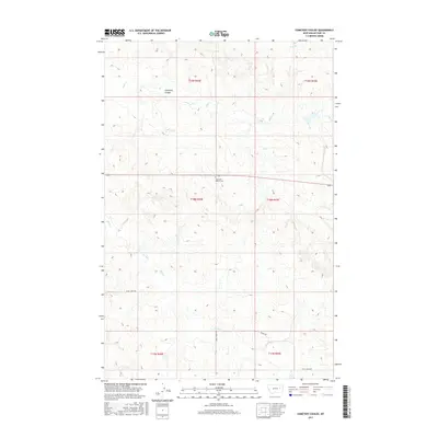
2017 Map of Cemetery Coulee
USGS Topo · Published 2017About this map
Haglunds Ritchie Cem serves as a central landmark in this sparse ranching landscape of eastern Montana. Located near the intersection of Highway 200, the cemetery is surrounded by the intricate drainage systems of Soda Cr and Cemetery Coulee. The terrain is characterized by dissected breaks and coulees, a common feature of the northern Missouri River watershed, where seasonal watercourses like Coal Cr and Skull Cr have carved out the landscape. Transport in this rural section of McCone County is defined by solitary routes such as Skull Creek Rd and Wilbur Rd. The map illustrates the persistent structure of the Public Land Survey System, dividing the area into the townships of T19N, T18N, and T17N across ranges 44E and 45E.
Find a feature on this map
14 named features on this map. Tap any name to fly to it.
Don’t see what you’re looking for? This feature index may not catch every label — zoom into the map to look around manually.
Map Details
Editions of this 2017 Cemetery Coulee Map
This is the sole edition of this map. No revisions or reprints were ever made.
Other maps of this area

1954 · Jordan
USGS Topo · 1:250,000

1954 · Glendive
USGS Topo · 1:250,000

1956 · Jordan
USGS Topo · 1:250,000

1957 · Glendive
USGS Topo · 1:250,000

1958 · Jordan
USGS Topo · 1:250,000

1958 · Glendive
USGS Topo · 1:250,000

1964 · Jordan
USGS Topo · 1:250,000

1965 · Hedstrom Lake
USGS Topo · 1:24,000

1965 · Hedstrom Lake NW
USGS Topo · 1:24,000
1965 · Berry School
USGS Topo · 1:24,000