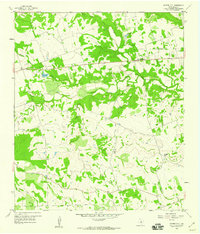
1959 Map of Center City
USGS Topo · Published 1960About this map
Center City serves as the primary settlement hub in this part of Mills County, where the historic Center City Cem and local school buildings once stood as community anchors. The landscape is defined by the complex drainage systems of North Bennett Creek, Middle Bennett Creek, and South Bennett Creek, which converge to form a branching network of valleys. Natural passages through the higher terrain are visible at Barr Gap and Russell Gap, providing strategic transit points for local travel. A prominent modern addition to this rural setting is a large Pipeline that cuts across the northern section of the map, illustrating the post-war industrial expansion into the Texas interior. Smaller water features like Kemp Lake and various seasonal draws like Bee Creek and Buckhorn Br further detail the local topography and land use patterns of the late 1950s.
Find a feature on this map
20 named features on this map. Tap any name to fly to it.
Don’t see what you’re looking for? This feature index may not catch every label — zoom into the map to look around manually.
Map Details
Editions of this 1959 Center City Map
This is the sole edition of this map. No revisions or reprints were ever made.
Other maps of this area

1885 · San Saba
USGS Topo · 1:125,000

1887 · Lampasas
USGS Topo · 1:125,000

1888 · Hamilton
USGS Topo · 1:125,000

1889 · Brownwood
USGS Topo · 1:125,000

1894 · Hamilton
USGS Topo · 1:125,000

1894 · Lampasas
USGS Topo · 1:125,000

1894 · Brownwood
USGS Topo · 1:125,000

1894 · San Saba
USGS Topo · 1:125,000

1925 · San Saba 1-d
USGS Topo · 1:48,000

1928 · Goldthwaite
USGS Topo · 1:62,500