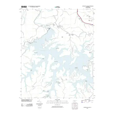
2010 Map of Center Hill Dam
USGS Topo · Published 2010About this map
Center Hill Dam anchors this landscape, regulating the waters of Caney Fork to create the branching reach of Cedar Hill Lake. This 2010 survey details a region where modern recreation and state-managed lands meet a deep-rooted rural geography. The southern portions of the map are defined by intricate coves and hollows, including Atnip Hollow and Poison Hollow, while the north preserves a network of family cemeteries that speak to the area's ancestral ties. Genealogists will find names like Pricnard Cemetery, Braswell Cemetery, and Carr Cemetery scattered across the ridges. The presence of Atnip Bluff Cabin Colony and various marinas such as Holmes Creek Dock highlights the area's development into a central hub for Tennessee water-based tourism, all while maintaining its original topographical character of steep ridges like Moss Ridge and Tucker Ridge.
Find a feature on this map
89 named features on this map. Tap any name to fly to it.
Don’t see what you’re looking for? This feature index may not catch every label — zoom into the map to look around manually.
Map Details
Editions of this 2010 Center Hill Dam Map
This is the sole edition of this map. No revisions or reprints were ever made.
Other maps of this area

1893 · Mc Minnville
USGS Topo · 1:125,000

1895 · Mc Minnville
USGS Topo · 1:125,000

1928 · Gordonsville
USGS Topo · 1:62,500

1942 · Statesville
USGS Topo · 1:100,000

1943 · Cookeville
USGS Topo · 1:100,000

1944 · Cookeville
USGS Topo · 1:100,000

1953 · Chattanooga
USGS Topo · 1:250,000

1955 · Baxter
USGS Topo · 1:24,000

1956 · Silver Point
USGS Topo · 1:24,000

1956 · Corbin
USGS Topo · 1:250,000