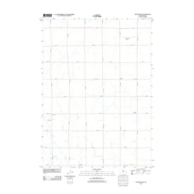
2012 Map of Center Point
USGS Topo · Published 2012About this map
Center Point sits at the heart of this rural landscape in Spring Valley Township, where the section-line grid of the Great Plains is punctuated by small, family-oriented landmarks and agricultural infrastructure. The territory is defined by the winding course of Turkey Cr, which cuts through the rectilinear road network of numbered streets and avenues. For those tracing family histories in Turner County, several local burial grounds are documented, including Evergreen Cem, Meldal Cem, Bethania Cem, and Hansen Cem, each serving as a focal point for the surrounding farmsteads. The presence of Turkey Ridge Airport in the northern portion of the quadrangle highlights the intersection of modern aviation with the traditional grain and livestock economy of southeastern South Dakota. This 2012 survey illustrates the enduring patterns of land use and the quiet significance of small prairie settlements.
Find a feature on this map
22 named features on this map. Tap any name to fly to it.
Don’t see what you’re looking for? This feature index may not catch every label — zoom into the map to look around manually.
Map Details
Editions of this 2012 Center Point Map
This is the sole edition of this map. No revisions or reprints were ever made.
Other maps of this area

1898 · Parker
USGS Topo · 1:125,000

1955 · Sioux Falls
USGS Topo · 1:250,000

1957 · Mayfield
USGS Topo · 1:24,000

1958 · Sioux Falls
USGS Topo · 1:250,000
1968 · Hurley
USGS Topo · 1:24,000

1968 · Parker SW
USGS Topo · 1:24,000
1968 · Wakonda
USGS Topo · 1:24,000
1968 · Viborg
USGS Topo · 1:24,000

1970 · Turkey Ridge
USGS Topo · 1:24,000

1970 · Freeman SE
USGS Topo · 1:24,000
Featured Places
- Spring Valley Township, SD
- Daneville Township, SD
- Turkey Valley Township, SD
- Swan Lake Township, SD
- Yankton County, SD