
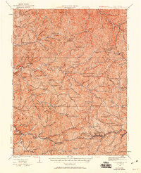
1924 Map of Centerpoint
USGS Topo · Published 1957About this map
Salem and the surrounding Doddridge County hill country appear here during a period of established rural density, with the Baltimore and Ohio RR serving as the primary corridor for commerce and travel. The map reveals a remarkably high concentration of neighborhood institutions, including dozens of local schoolhouses such as the Golden Don School and Flinderation School, which were once the social anchors for families farming along the numerous runs and forks.
Find a feature on this map
157 named features on this map. Tap any name to fly to it.
Don’t see what you’re looking for? This feature index may not catch every label — zoom into the map to look around manually.
Map Details
Editions of this 1924 Centerpoint Map
2 editions found
Other maps of this area

1902 · Clarksburg
USGS Topo · 1:62,500

1903 · Littleton
USGS Topo · 1:62,500

1904 · Weston
USGS Topo · 1:62,500

1904 · Vadis
USGS Topo · 1:62,500

1905 · Mannington
USGS Topo · 1:62,500

1905 · Centerpoint
USGS Topo · 1:62,500

1905 · West Union
USGS Topo · 1:62,500

1905 · Littleton
USGS Topo · 1:62,500

1906 · Holbrook
USGS Topo · 1:62,500

1906 · New Martinsville
USGS Topo · 1:62,500