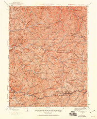
1924 Map of Centerpoint
USGS Topo · Published 1960About this map
The Baltimore and Ohio railroad corridor anchors the southern portion of this landscape, connecting the industrial nodes of Salem, Industrial, and Smithton Smithburg Sta. In this 1920s-era revision of the territory where Doddridge, Harrison, Tyler, and Wetzel Counties converge, the map reveals a dense network of mountain communities and decentralized schoolhouses. Settlements such as Centerpoint, Sedalia, and Blandville are interspersed among dozens of rural education sites like Broad Run School and Golden Don School, reflecting the era's reliance on localized community hubs.
Find a feature on this map
133 named features on this map. Tap any name to fly to it.
Don’t see what you’re looking for? This feature index may not catch every label — zoom into the map to look around manually.
Map Details
Editions of this 1924 Centerpoint Map
2 editions found

Other maps of this area

1902 · Clarksburg
USGS Topo · 1:62,500

1903 · Littleton
USGS Topo · 1:62,500

1904 · Weston
USGS Topo · 1:62,500

1904 · Vadis
USGS Topo · 1:62,500

1905 · Mannington
USGS Topo · 1:62,500

1905 · Centerpoint
USGS Topo · 1:62,500

1905 · West Union
USGS Topo · 1:62,500

1905 · Littleton
USGS Topo · 1:62,500

1906 · Holbrook
USGS Topo · 1:62,500

1906 · New Martinsville
USGS Topo · 1:62,500