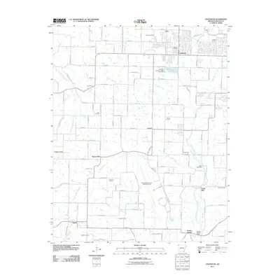
2011 Map of Centerton
USGS Topo · Published 2011About this map
Centerton and the surrounding Benton County landscape are shown here during a period of significant regional transition, where traditional agricultural roots meet modern infrastructure. The presence of the Northwest Arkansas Regional Airport in the southern half of the map marks the area's role as a transportation hub, while older settlements like Vaughn, Mason Valley, and Seba reflect the long-standing rural community structure. Waterways such as Little Osage Creek and McKisic Creek anchor the landscape, providing the location for historic industry and landmarks like the Osage Mills Dam and Centerton Hatchery Upper Pond Dam. Family and community history is deeply etched into the land through numerous burial grounds, including the Coffelt Cemetery, Barron Cemetery, and Armstrong Cemetery. The mapping of small hamlets such as Highfill and Osage Mills provides researchers a look at how early milling and spring-side settlements integrated with the developing road network.
Find a feature on this map
146 named features on this map. Tap any name to fly to it.
Don’t see what you’re looking for? This feature index may not catch every label — zoom into the map to look around manually.
Map Details
Editions of this 2011 Centerton Map
This is the sole edition of this map. No revisions or reprints were ever made.
Other maps of this area

1899 · Fayetteville
USGS Topo · 1:125,000

1901 · Fayetteville
USGS Topo · 1:125,000

1904 · Fayetteville
USGS Topo · 1:125,000

1954 · Tulsa
USGS Topo · 1:250,000

1958 · Tulsa
USGS Topo · 1:250,000

1963 · Tulsa
USGS Topo · 1:250,000

1970 · Gallatin
USGS Topo · 1:24,000

1970 · Robinson
USGS Topo · 1:24,000
1970 · Bentonville South
USGS Topo · 1:24,000
1970 · Bentonville North
USGS Topo · 1:24,000