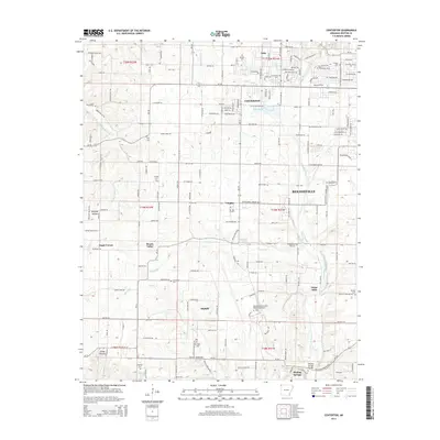
2014 Map of Centerton
USGS Topo · Published 2014About this map
Centerton and the western reaches of Bentonville anchor this 2014 survey, which documents the rapid modernization of Benton County. A significant portion of the landscape is dominated by the Northwest Arkansas Regional Airport, its sprawling runways and associated infrastructure situated between the rural crossroads of Highfill and Vaughn. This modern development sits in contrast to the historical network of family-named cemeteries and small agrarian settlements that define the region's earlier character, such as Mason Valley and Seba.
Find a feature on this map
196 named features on this map. Tap any name to fly to it.
Don’t see what you’re looking for? This feature index may not catch every label — zoom into the map to look around manually.
Map Details
Editions of this 2014 Centerton Map
This is the sole edition of this map. No revisions or reprints were ever made.
Other maps of this area

1899 · Fayetteville
USGS Topo · 1:125,000

1901 · Fayetteville
USGS Topo · 1:125,000

1904 · Fayetteville
USGS Topo · 1:125,000

1954 · Tulsa
USGS Topo · 1:250,000

1958 · Tulsa
USGS Topo · 1:250,000

1963 · Tulsa
USGS Topo · 1:250,000

1970 · Gallatin
USGS Topo · 1:24,000

1970 · Robinson
USGS Topo · 1:24,000
1970 · Bentonville South
USGS Topo · 1:24,000
1970 · Bentonville North
USGS Topo · 1:24,000