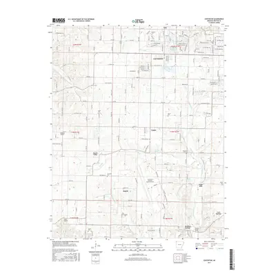
2017 Map of Centerton
USGS Topo · Published 2017About this map
Centerton and its surrounding communities in Benton County are defined by the convergence of traditional rural landscape and modern aviation infrastructure. The expansive footprint of the Northwest Arkansas Regional Airport occupies the southern half of the quadrangle, bordering the older settlement at Highfill. This region, characterized by its numerous natural water sources, includes the namesake Healing Springs and Bluff Spring, along with the headwaters of Little Osage Creek and Spavinaw Creek. These watercourses historically supported small communities like Osage Mills and Vaughn. For genealogists, the map preserves the locations of several historic burial grounds, including the Armstrong Cemetery in Mason Valley and the Coffelt Cemetery, which provide geographical anchors for the families that settled this portion of the Ozark plateau.
Find a feature on this map
186 named features on this map. Tap any name to fly to it.
Don’t see what you’re looking for? This feature index may not catch every label — zoom into the map to look around manually.
Map Details
Editions of this 2017 Centerton Map
This is the sole edition of this map. No revisions or reprints were ever made.
Other maps of this area

1899 · Fayetteville
USGS Topo · 1:125,000

1901 · Fayetteville
USGS Topo · 1:125,000

1904 · Fayetteville
USGS Topo · 1:125,000

1954 · Tulsa
USGS Topo · 1:250,000

1958 · Tulsa
USGS Topo · 1:250,000

1963 · Tulsa
USGS Topo · 1:250,000

1970 · Gallatin
USGS Topo · 1:24,000

1970 · Robinson
USGS Topo · 1:24,000
1970 · Bentonville South
USGS Topo · 1:24,000
1970 · Bentonville North
USGS Topo · 1:24,000