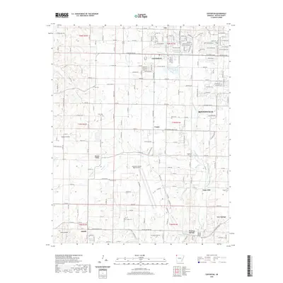
2020 Map of Centerton
USGS Topo · Published 2020About this map
Centerton and the surrounding Benton County landscape are defined by a complex network of spring-fed waterways and established rural settlements. The headwaters of Spavinaw Creek and the winding course of Little Osage Creek drain this upland region, which has long transitioned from a strictly agricultural frontier to a modern transport hub centered on the Northwest Arkansas Regional Airport. Local history is anchored by numerous burial grounds such as Gamble Cemetery and Armstrong Cemetery, which serve as physical markers of family lineages in communities like Vaughn and Mason Valley. The map reveals the area's geological character through features like Bluff Spring and Healing Springs, while the inclusion of Osage Mills points to an earlier era of water-powered industry that once shaped the local economy before the rapid expansion of nearby Bentonville.
Find a feature on this map
200 named features on this map. Tap any name to fly to it.
Don’t see what you’re looking for? This feature index may not catch every label — zoom into the map to look around manually.
Map Details
Editions of this 2020 Centerton Map
This is the sole edition of this map. No revisions or reprints were ever made.
Other maps of this area

1899 · Fayetteville
USGS Topo · 1:125,000

1901 · Fayetteville
USGS Topo · 1:125,000

1904 · Fayetteville
USGS Topo · 1:125,000

1954 · Tulsa
USGS Topo · 1:250,000

1958 · Tulsa
USGS Topo · 1:250,000

1963 · Tulsa
USGS Topo · 1:250,000

1970 · Gallatin
USGS Topo · 1:24,000

1970 · Robinson
USGS Topo · 1:24,000
1970 · Bentonville South
USGS Topo · 1:24,000
1970 · Bentonville North
USGS Topo · 1:24,000