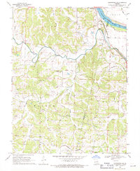
1969 Map of Centertown NW
USGS Topo · Published 1971About this map
Moniteau Creek and the Missouri Pacific railroad dominate this late 1960s landscape, illustrating the critical transportation corridors that defined central Missouri. Near the confluence of the Missouri River and the creek, the small settlement of Sandy Hook sits protected by a Levee, while further south the town of Centertown anchors the rail line. The map reveals a dense network of rural community centers, including Shiloh Ch and New Hope Ch, alongside numerous family and community burial grounds such as Chapel Cem and Sweetwater Cem. Evidence of much earlier habitation is preserved in the form of Indian Mounds and an Indian Mound located near the river bluffs. The transition from the rugged drainage basins of Haldiman Branch and Hauck Branch to the flatter farmland of Linn and Walker townships showcases the varied agricultural potential of Moniteau County during this era.
Find a feature on this map
39 named features on this map. Tap any name to fly to it.
Don’t see what you’re looking for? This feature index may not catch every label — zoom into the map to look around manually.
Map Details
Editions of this 1969 Centertown NW Map
This is the sole edition of this map. No revisions or reprints were ever made.
Other maps of this area

1886 · Jefferson City
USGS Topo · 1:125,000

1888 · Boonville
USGS Topo · 1:125,000

1894 · Jefferson City
USGS Topo · 1:125,000

1947 · Jefferson City
USGS Topo · 1:250,000

1948 · Centertown
USGS Topo · 1:62,500

1948 · Columbia
USGS Topo · 1:62,500
1949 · Centertown
USGS Topo · 1:62,500

1950 · Columbia
USGS Topo · 1:62,500

1951 · California South
USGS Topo · 1:24,000
1952 · Prairie Home
USGS Topo · 1:24,000