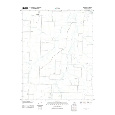
2011 Map of Centerview
USGS Topo · Published 2011About this map
Centerview serves as the primary hub in this rural landscape within Johnson County, where the grid of county roads intersects with the branching drainage of the West Fork Post Oak Creek and East Fork Post Oak Creek. The 2011 survey highlights a persistent pattern of rural community life, marked by numerous educational and commemorative sites that speak to the area's local genealogy. Historic rural schoolhouses like Locust Grove School, Science Hill School, and Hazel Mound School are preserved in the records alongside established burial grounds such as Sluder Cemetery and Pisgah Cemetery. In the northern reaches, Lions Lake provides a notable water feature near the edge of the more developed areas, while the landscape further south remains dominated by agricultural parcels and smaller named locations like Scott. The network of roads, including SW 800th RD and SW 100th RD, links these disparate landmarks across a terrain defined by subtle elevation changes and numerous creek branches like Bradley Branch and Fletcher Creek.
Find a feature on this map
34 named features on this map. Tap any name to fly to it.
Don’t see what you’re looking for? This feature index may not catch every label — zoom into the map to look around manually.
Map Details
Editions of this 2011 Centerview Map
This is the sole edition of this map. No revisions or reprints were ever made.
Other maps of this area

1885 · Warrensburg
USGS Topo · 1:125,000

1887 · Warrensburg
USGS Topo · 1:125,000

1894 · Warrensburg
USGS Topo · 1:125,000

1917 · Knobnoster
USGS Topo · 1:62,500

1947 · Jefferson City
USGS Topo · 1:250,000

1954 · Jefferson City
USGS Topo · 1:250,000

1954 · Centerview
USGS Topo · 1:24,000
1954 · Holden
USGS Topo · 1:24,000
1955 · Leeton
USGS Topo · 1:24,000

1955 · Cornelia
USGS Topo · 1:24,000