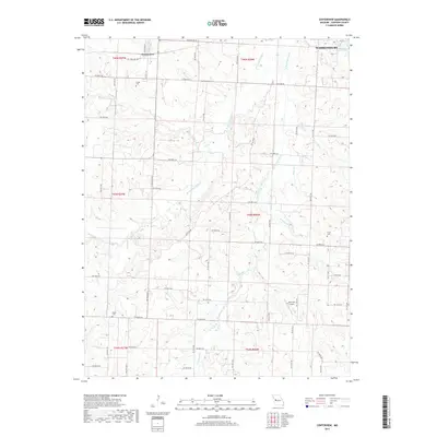
2017 Map of Centerview
USGS Topo · Published 2017About this map
Centerview serves as the central hub for this rural Johnson County landscape, situated west of the expanding edge of Warrensburg. The area is defined by the branching tributaries of Post Oak Creek, including the W Fork Post Oak Cr and the East Fork Post Oak Creek, which create a rolling drainage pattern through the agricultural sections. Small family and community landmarks are scattered across the townships, such as Sluder Cem in the north and Pisgah Cem to the south. Near the northeastern corner, the recreational waters of Lions Lake and the grounds of Pertle Springs transition from the town's edge into the more open country. A legacy of flight is preserved at the Short Air Airport, located near the intersection of several county roads that grid the territory between Hogan Fork and Fletcher Cr.
Find a feature on this map
43 named features on this map. Tap any name to fly to it.
Don’t see what you’re looking for? This feature index may not catch every label — zoom into the map to look around manually.
Map Details
Editions of this 2017 Centerview Map
This is the sole edition of this map. No revisions or reprints were ever made.
Other maps of this area

1885 · Warrensburg
USGS Topo · 1:125,000

1887 · Warrensburg
USGS Topo · 1:125,000

1894 · Warrensburg
USGS Topo · 1:125,000

1917 · Knobnoster
USGS Topo · 1:62,500

1947 · Jefferson City
USGS Topo · 1:250,000

1954 · Jefferson City
USGS Topo · 1:250,000

1954 · Centerview
USGS Topo · 1:24,000
1954 · Holden
USGS Topo · 1:24,000
1955 · Leeton
USGS Topo · 1:24,000

1955 · Cornelia
USGS Topo · 1:24,000