
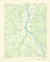
1936 Map of Centerville Landing
USGS Topo · Published 1936About this map
The Tennessee River serves as the dominant artery of this 1936 landscape, a time when numerous river landings like Paris Landing and Centerville Landing still defined the local transport economy. This Tennessee Valley Authority survey captures the confluence with the Big Sandy River and its intricate network of sloughs and islands, including Big Sandy Island. The map reveals a deeply etched terrain of hollows—such as Wofford Hollow and Mullins Hollow—which supported a dispersed rural community connected by small schools and churches. Genealogists will find a wealth of specific landmarks, including Old Maple Grove Ch, St Mary Ch, and family-named burial grounds like Wofford Cem. The spanning of the river by the Scott Fitzhugh Bridge along State Highway No 76 marks the modernization of transit through the river bottomlands just before significant hydrological changes altered this region.
Find a feature on this map
82 named features on this map. Tap any name to fly to it.
Don’t see what you’re looking for? This feature index may not catch every label — zoom into the map to look around manually.
Map Details
Editions of this 1936 Centerville Landing Map
2 editions found
Other maps of this area

1936 · Poplar Creek
USGS Topo · 1:24,000

1936 · Buchanan
USGS Topo · 1:24,000

1936 · Tharpe
USGS Topo · 1:24,000

1936 · New Concord
USGS Topo · 1:24,000

1936 · McKinnon
USGS Topo · 1:24,000

1936 · Hamlin
USGS Topo · 1:24,000

1936 · Standing Rock
USGS Topo · 1:24,000

1936 · Springville
USGS Topo · 1:24,000

1938 · Springville
USGS Topo · 1:24,000

1942 · New Concord
USGS Topo · 1:24,000