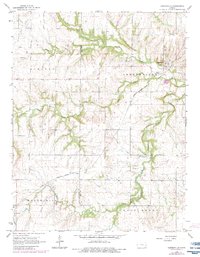
1966 Map of Centerville
USGS Topo · Published 1983About this map
The Missouri - Kansas - Texas railroad corridor defines the mid-century industrial and transport landscape of this rural Kansas border region. Centered on the town of Centerville, the landscape is a network of watercourses including Sugar Creek, Saline Creek, and the South Fork Sugar Creek. Rural life is marked by small settlements like Selma and Vance, alongside community landmarks such as Oakwood Cem and a central Water Tank. Economic activity is driven by natural resource extraction, evident in the extensive Oil Field and scattered Oil Wells across the western townships. The topography is also shaped by extractive industry, with several Gravel Pit locations and a Quarry appearing near the county line. This survey captures a moment of transition where traditional agrarian patterns coexist with the infrastructure of the regional oil and rail economy.
Find a feature on this map
21 named features on this map. Tap any name to fly to it.
Don’t see what you’re looking for? This feature index may not catch every label — zoom into the map to look around manually.
Map Details
Editions of this 1966 Centerville Map
2 editions found
Other maps of this area

1885 · Garnett
USGS Topo · 1:125,000

1887 · Mound City
USGS Topo · 1:125,000

1893 · Mound City
USGS Topo · 1:125,000

1894 · Garnett
USGS Topo · 1:125,000

1947 · Lawrence
USGS Topo · 1:250,000

1950 · Lawrence
USGS Topo · 1:250,000

1956 · Lawrence
USGS Topo · 1:250,000

1961 · Lawrence
USGS Topo · 1:250,000

1963 · Parker
USGS Topo · 1:24,000
1966 · Mound City NW
USGS Topo · 1:24,000