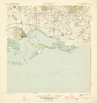
1945 Map of Central Aguirre
USGS Topo · Published 1945About this map
Sugarcane production dominates the coastal landscape of southern Puerto Rico in this mid-1940s survey, centered on the vital port and mill at Central Aguirre. The industrial infrastructure of the era is clearly visible through the Central Guamaní railroad lines and the extensive irrigation network of the Canal de Patillas and Canal de Guamaní, which feed the surrounding fields. The coastline is defined by the protected waters of Bahía de Jobos, shielded from the Mar Caribe by an intricate system of mangroves and islets including the Cayos de Barca and Cayos Caribes.
Find a feature on this map
39 named features on this map. Tap any name to fly to it.
Don’t see what you’re looking for? This feature index may not catch every label — zoom into the map to look around manually.
Map Details
Editions of this 1945 Central Aguirre Map
3 editions found
Other maps of this area

1945 · Central Aguirre
USGS Topo · 1:30,000

1945 · Salinas
USGS Topo · 1:30,000

1946 · Patillas
USGS Topo · 1:30,000

1946 · Coamo
USGS Topo · 1:30,000

1946 · Cayey
USGS Topo · 1:30,000

1946 · Guayama
USGS Topo · 1:30,000

1947 · Patillas SO
USGS Topo · 1:10,000
1947 · Guayama NO
USGS Topo · 1:10,000
1947 · Central Aguirre NE
USGS Topo · 1:10,000

1947 · Cayey SO
USGS Topo · 1:10,000
Featured Places
- Cimarrona, Guayama
- Parcelas Viejas de Cimarrona, Guayama
- Estancias de Villa Hermosa, Guayama
- Reunión, Guayama
- Las Mareas, Guayama