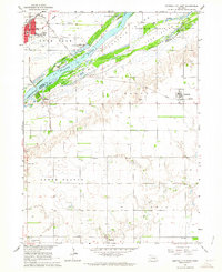
1962 Map of Central City East
USGS Topo · Published 1964About this map
Platte River braided channels dominate this 1962 landscape, creating a complex network of islands and floodplains including Prairie Island, Island No 1, and Island No 2. This survey, conducted as part of the Missouri River Basin development program, captures the rural transition between Merrick and Hamilton Counties. Agricultural life is anchored by small settlements like Kronborg and Hordville, while the northern portion is defined by the Union Pacific rail corridor and the growth of Central City. Local social history is preserved through the mapping of the Hord Sch, Mamre Ch, and Mt Zion Cem. The geography also reflects mid-century leisure and infrastructure, from the Hord Lake State Recreation Area and Covenant Cedars Camp to the Bankson Airport, situated atop the bluff overlooking the river valley.
Find a feature on this map
32 named features on this map. Tap any name to fly to it.
Don’t see what you’re looking for? This feature index may not catch every label — zoom into the map to look around manually.
Map Details
Editions of this 1962 Central City East Map
2 editions found
Other maps of this area

1896 · Stromsburg
USGS Topo · 1:125,000

1898 · York
USGS Topo · 1:125,000

1898 · Grand Island
USGS Topo · 1:125,000

1899 · St. Paul
USGS Topo · 1:125,000

1899 · York
USGS Topo · 1:125,000

1955 · Broken Bow
USGS Topo · 1:250,000

1955 · Fremont
USGS Topo · 1:250,000

1955 · Lincoln
USGS Topo · 1:250,000

1955 · Grand Island
USGS Topo · 1:250,000

1956 · Broken Bow
USGS Topo · 1:250,000