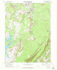
1971 Map of Central City
USGS Topo · Published 1972About this map
Industrial extraction and recreational development define this 1971 landscape on the Allegheny Front. Central City and Cairnbrook serve as the primary hubs of activity, where the infrastructure of the coal industry is evident in numerous mines, a Tipple, and several Mine Dumps. The Penn Central railroad winds through these communities, illustrating the critical link between the local resource economy and broader transport networks. South of the mining district, the development of Indian Lake and Lake Stonycreek indicates a shift toward leisure and residential use, complete with a Golf Course and the Indian Lake Airport.
Find a feature on this map
45 named features on this map. Tap any name to fly to it.
Don’t see what you’re looking for? This feature index may not catch every label — zoom into the map to look around manually.
Map Details
Editions of this 1971 Central City Map
2 editions found
Other maps of this area

1908 · Bedford
USGS Topo · 1:62,500

1910 · Bedford
USGS Topo · 1:62,500

1914 · Windber
USGS Topo · 1:62,500

1916 · Windber
USGS Topo · 1:62,500

1923 · Berlin
USGS Topo · 1:48,000

1927 · Hyndman
USGS Topo · 1:62,500

1929 · Berlin
USGS Topo · 1:62,500

1931 · Hyndman
USGS Topo · 1:62,500

1944 · Hyndman
USGS Topo · 1:62,500

1944 · Windber
USGS Topo · 1:62,500