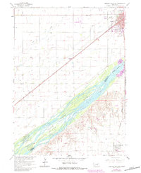
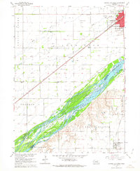
1962 Map of Central City West
USGS Topo · Published 1984About this map
The Platte River defines the central axis of this Nebraska landscape, where an intricate network of braided channels and the large Bushes Island mark the Merrick Co Hamilton Co line. North of the river, Central City serves as a significant regional hub, oriented along the Union Pacific tracks. This rail corridor is mirrored by a series of irrigation and drainage features, including Silver Creek and Warm Slough, which support the intensive agriculture of the plains. Educational landmarks like School No 8 and School No 12 are distributed across the rural township grid, while the southern portion of the map shows the community of Marquette near the Burlington Northern line. The map illustrates the 1960s infrastructure of the Missouri River Basin, including the Central City Municipal Airport and several industrial Gravel Pit operations near the river's edge.
Find a feature on this map
21 named features on this map. Tap any name to fly to it.
Don’t see what you’re looking for? This feature index may not catch every label — zoom into the map to look around manually.
Map Details
Editions of this 1962 Central City West Map
2 editions found
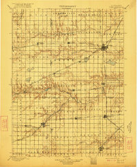
Other maps of this area

1896 · Stromsburg
USGS Topo · 1:125,000

1898 · York
USGS Topo · 1:125,000

1898 · Grand Island
USGS Topo · 1:125,000

1899 · St. Paul
USGS Topo · 1:125,000
1899 · York
USGS Topo · 1:125,000

1955 · Broken Bow
USGS Topo · 1:250,000

1955 · Fremont
USGS Topo · 1:250,000

1955 · Lincoln
USGS Topo · 1:250,000

1955 · Grand Island
USGS Topo · 1:250,000

1956 · Broken Bow
USGS Topo · 1:250,000