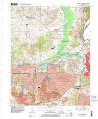
1997 Map of Central City West
USGS Topo · Published 2001About this map
Bremen and South Carrollton anchor a landscape defined by significant industrial modification and natural conservation in Muhlenberg County. The map details an era where the Green River and its tributaries, including Muddy Fork, coexist with massive land reclamation efforts. Expansive Strip Mines dominate much of the southern and central terrain, contrasted by the established Peabody State Wildlife Management Area. Local history is preserved through small rural hubs like Gishton and Midland, and family history researchers can find several notable landmarks such as Shavers Chapel and Bethlehem Cem. The transit corridor of the Western Kentucky Parkway bisects the southern mining district, illustrating the region's connection to larger state infrastructure during the late 20th century.
Find a feature on this map
26 named features on this map. Tap any name to fly to it.
Don’t see what you’re looking for? This feature index may not catch every label — zoom into the map to look around manually.
Map Details
Editions of this 1997 Central City West Map
This is the sole edition of this map. No revisions or reprints were ever made.
Other maps of this area

1909 · Madisonville
USGS Topo · 1:62,500

1909 · Central City
USGS Topo · 1:62,500

1911 · Drakesboro
USGS Topo · 1:48,000

1912 · Nortonville
USGS Topo · 1:62,500

1913 · Drakesboro
USGS Topo · 1:62,500

1952 · Equality
USGS Topo · 1:24,000

1952 · Livermore
USGS Topo · 1:24,000

1952 · Sacramento
USGS Topo · 1:24,000

1952 · Greenville
USGS Topo · 1:24,000

1953 · Drakesboro
USGS Topo · 1:24,000