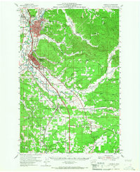
1954 Map of Centralia
USGS Topo · Published 1967About this map
The Chehalis River valley serves as a bustling corridor for mid-century transportation and commerce, dominated by the neighboring hubs of Centralia and Chehalis. This mid-1950s landscape is defined by its extensive rail infrastructure, where the Northern Pacific, Union Pacific, and Great Northern railroads converge. While the river bottoms support urban growth and the Fairgrounds, the surrounding uplands like Newaukum Hill and Logan Hill maintain a more rural character of prairies and timbered ridges.
Find a feature on this map
65 named features on this map. Tap any name to fly to it.
Don’t see what you’re looking for? This feature index may not catch every label — zoom into the map to look around manually.
Map Details
Editions of this 1954 Centralia Map
2 editions found

Other maps of this area

1916 · Chehalis
USGS Topo · 1:125,000

1940 · Tenino
USGS Topo · 1:62,500

1941 · Meskill
USGS Topo · 1:62,500

1941 · Olequa
USGS Topo · 1:62,500

1941 · Gate
USGS Topo · 1:62,500

1942 · Toutle
USGS Topo · 1:62,500

1943 · Willapa
USGS Topo · 1:62,500

1944 · Tenino
USGS Topo · 1:62,500

1944 · Yelm
USGS Topo · 1:62,500

1949 · Yelm
USGS Topo · 1:62,500