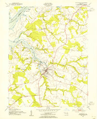
1954 Map of Centreville
USGS Topo · Published 1955About this map
Centreville serves as the focal point of this Eastern Shore survey, situated where the Yellow Bank Str and Mill Stream converge. The town's mid-century layout is detailed, featuring the High Sch and Kennard Sch, alongside the Pennsylvania railroad line terminating near the commercial core. This era of the Tidewater landscape shows a deep reliance on the winding waterways of the Corsica River and Chester River, where points like Ashland Ldg and Centreville Landing marked critical interfaces between land and water.
Find a feature on this map
56 named features on this map. Tap any name to fly to it.
Don’t see what you’re looking for? This feature index may not catch every label — zoom into the map to look around manually.
Map Details
Editions of this 1954 Centreville Map
3 editions found
Other maps of this area

1898 · Choptank
USGS Topo · 1:125,000

1898 · Tolchester
USGS Topo · 1:125,000

1899 · Dover
USGS Topo · 1:125,000

1901 · Chestertown
USGS Topo · 1:62,500

1903 · Tolchester
USGS Topo · 1:125,000

1904 · St. Michaels
USGS Topo · 1:62,500

1905 · Denton
USGS Topo · 1:62,500

1905 · Barclay
USGS Topo · 1:62,500

1906 · Dover
USGS Topo · 1:125,000

1908 · Tolchester
USGS Topo · 1:125,000