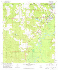
1978 Map of Century
USGS Topo · Published 1978About this map
The Escambia River meanders across this northern Florida landscape, forming a critical natural boundary between Escambia and Santa Rosa counties. In the late 1970s, the town of Century serves as a local hub of civic and social life, anchored by the County Courthouse, Carver High Sch, and an Athletic Field. To the north, the community of Flomaton sits right at the Alabama border, where the Louisville and Nashville railroad tracks cross into the neighboring state.
Find a feature on this map
55 named features on this map. Tap any name to fly to it.
Don’t see what you’re looking for? This feature index may not catch every label — zoom into the map to look around manually.
Map Details
Editions of this 1978 Century Map
This is the sole edition of this map. No revisions or reprints were ever made.
Other maps of this area

1941 · Century
USGS Topo · 1:62,500

1943 · Century
USGS Topo · 1:62,500

1943 · Jay
USGS Topo · 1:62,500

1953 · Andalusia
USGS Topo · 1:250,000

1957 · Andalusia
USGS Topo · 1:250,000

1957 · Pensacola
USGS Topo · 1:250,000

1959 · Pensacola
USGS Topo · 1:250,000

1960 · Pensacola
USGS Topo · 1:250,000

1960 · Atmore
USGS Topo · 1:24,000

1960 · Pollard
USGS Topo · 1:24,000