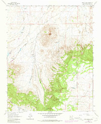
1963 Map of Cerro Alesna
USGS Topo · Published 1981About this map
Cerro Alesna stands as a prominent volcanic landmark within the high desert landscape of McKinley County, as shown in this 1960s-era survey updated in the early 1980s. The map documents the overlap of the Bartolome Fernandez land grant with the eastern edge of the Cibola National Forest. While the terrain is defined by dry drainage systems like San Isidro Arroyo and Cañon del Dado, human activity is concentrated around scattered water sources and seasonal tanks. Historians can locate the Fort San Miguel (Ruins) and the nearby San Miguel Ranch, suggesting a long-standing pattern of ranching and settlement along the San Miguel watercourse. In the northwest, the benchmark at Burns BM 6798 and the Telesfors Tank indicate the vital role of specific local water management in this arid environment.
Find a feature on this map
31 named features on this map. Tap any name to fly to it.
Don’t see what you’re looking for? This feature index may not catch every label — zoom into the map to look around manually.
Map Details
Editions of this 1963 Cerro Alesna Map
2 editions found
Other maps of this area

1883 · Mt. Taylor
USGS Topo · 1:250,000

1886 · Mt. Taylor
USGS Topo · 1:250,000

1892 · Mt. Taylor
USGS Topo · 1:250,000

1899 · Mt. Taylor
USGS Topo · 1:250,000

1958 · Albuquerque
USGS Topo · 1:250,000

1961 · El Dado
USGS Topo · 1:24,000

1961 · Piedra De La Aguila
USGS Topo · 1:24,000

1961 · El Dado Mesa
USGS Topo · 1:24,000
1961 · Laguna Canoneros
USGS Topo · 1:24,000
1961 · Mesa Cortada
USGS Topo · 1:24,000