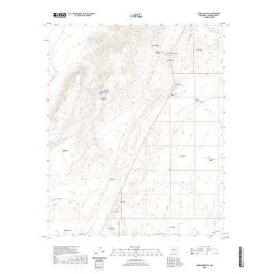
2020 Map of Cerro Montoso
USGS Topo · Published 2020About this map
Cerro Montoso and the Los Pinos Mountains anchor this arid Socorro County landscape, where the topography is defined by a complex system of volcanic peaks and deeply carved drainage patterns. The high elevations of Cerro Pelon and the surrounding Grey Ridge transition into lower basins marked by alluvial features such as Entraniosa Draw and Patterson Draw. Evidence of cattle ranching and water management in this high-desert environment is visible through scattered infrastructure, notably John Renlods Tank and Patterson Tank. Access across this part of New Mexico is maintained by several long-standing routes, including Co RD 121 and the military-associated WSMR S Route 3810, which trace the valleys between Red Mesa and the northern canyons like Pinon Canyon.
Find a feature on this map
26 named features on this map. Tap any name to fly to it.
Don’t see what you’re looking for? This feature index may not catch every label — zoom into the map to look around manually.
Map Details
Editions of this 2020 Cerro Montoso Map
This is the sole edition of this map. No revisions or reprints were ever made.
Other maps of this area

1916 · La Joya
USGS Topo · 1:125,000

1952 · Black Butte
USGS Topo · 1:24,000

1952 · Becker SW
USGS Topo · 1:24,000

1952 · Becker
USGS Topo · 1:24,000

1952 · Cerro Montoso
USGS Topo · 1:24,000

1954 · Socorro
USGS Topo · 1:250,000

1958 · Socorro
USGS Topo · 1:250,000

1962 · Socorro
USGS Topo · 1:250,000
1972 · Sierra Larga North
USGS Topo · 1:24,000
1972 · Sierra De La Cruz
USGS Topo · 1:24,000