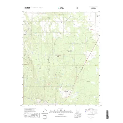
2020 Map of Cerro Pelon
USGS Topo · Published 2020About this map
Cibola National Forest encompasses the high-altitude volcanic landscape of northwestern New Mexico, dominated by the prominent peaks of Cerro Pelon and Cerro Osha. This terrain is characterized by a series of deep drainages including San Mateo Canyon and San Lucas Canyon, which fall away from the massive Mesa Chivato. The map documents a complex network of forest service roads and the Continental Divide National Scenic Trail, which winds through the central portion of the quadrangle near Spud Patch Canyon. High-country water management is evident through numerous named collection points like Llanito Frio Tanks and Antelope Tank, as well as several springs such as Elkins Spring and Manuel Spring. The boundary between McKinley and Cibola counties bisects the region, reflecting the administrative divisions of this remote mountain landscape where headwaters like Seboyetita Cr and the Rio Paguate originate.
Find a feature on this map
59 named features on this map. Tap any name to fly to it.
Don’t see what you’re looking for? This feature index may not catch every label — zoom into the map to look around manually.
Map Details
Editions of this 2020 Cerro Pelon Map
This is the sole edition of this map. No revisions or reprints were ever made.
Other maps of this area

1883 · Mt. Taylor
USGS Topo · 1:250,000

1886 · Mt. Taylor
USGS Topo · 1:250,000

1892 · Mt. Taylor
USGS Topo · 1:250,000

1899 · Mt. Taylor
USGS Topo · 1:250,000

1957 · Lobo Springs
USGS Topo · 1:24,000

1957 · Mount Taylor
USGS Topo · 1:24,000

1957 · Seboyeta
USGS Topo · 1:24,000

1958 · Albuquerque
USGS Topo · 1:250,000

1961 · El Dado Mesa
USGS Topo · 1:24,000
1961 · Laguna Canoneros
USGS Topo · 1:24,000