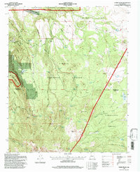
1995 Map of Cerro Pelon
USGS Topo · Published 1997About this map
Bartolome Fernandez Grant and the San Mateo Springs Grant define the land ownership patterns of this high-elevation terrain, where large historical land grants meet the boundaries of the Cibola National Forest. The landscape is dominated by volcanic features and high plateaus, including Chivato Mesa and the prominent heights of Cerro Pelon and Cerro Osha. Water management is central to the area's utility, evidenced by a high density of named water sources such as San Lucas Spring, Effran Tank, and the Llanito Frio Tanks.
Find a feature on this map
48 named features on this map. Tap any name to fly to it.
Don’t see what you’re looking for? This feature index may not catch every label — zoom into the map to look around manually.
Map Details
Editions of this 1995 Cerro Pelon Map
This is the sole edition of this map. No revisions or reprints were ever made.
Other maps of this area

1883 · Mt. Taylor
USGS Topo · 1:250,000

1886 · Mt. Taylor
USGS Topo · 1:250,000

1892 · Mt. Taylor
USGS Topo · 1:250,000

1899 · Mt. Taylor
USGS Topo · 1:250,000

1957 · Lobo Springs
USGS Topo · 1:24,000

1957 · Mount Taylor
USGS Topo · 1:24,000

1957 · Seboyeta
USGS Topo · 1:24,000

1958 · Albuquerque
USGS Topo · 1:250,000

1961 · El Dado Mesa
USGS Topo · 1:24,000
1961 · Laguna Canoneros
USGS Topo · 1:24,000