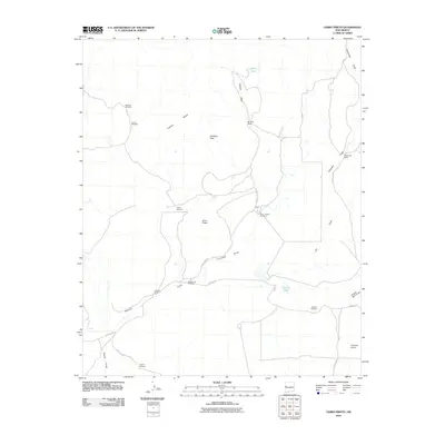
2010 Map of Cerro Prieto
USGS Topo · Published 2010About this map
Montano Ranch and Hubbell Ranch anchor a landscape defined by ranching operations and water management in this high-desert portion of Cibola County. The terrain is marked by prominent natural features such as Cerro Prieto, Hawkins Peak, and the expansive Flattop Mesa. Water access, critical for survival and livestock in this arid environment, is meticulously documented through a network of windmills and seasonal drainages. Facilities like the Martinez Windmill, Cerro Prieto Windmill, and Dipping Vat Windmill trace the infrastructure of the local cattle industry. A series of natural ephemeral watercourses, including Frenches Draw and Nations Draw, cut through the landscape toward catchments like Garcia Lake. This 2010 survey illustrates the persistence of traditional land use and family-named landmarks across a vast, sparsely populated territory.
Find a feature on this map
29 named features on this map. Tap any name to fly to it.
Don’t see what you’re looking for? This feature index may not catch every label — zoom into the map to look around manually.
Map Details
Editions of this 2010 Cerro Prieto Map
This is the sole edition of this map. No revisions or reprints were ever made.
Other maps of this area

1954 · Saint Johns
USGS Topo · 1:250,000

1957 · Saint Johns
USGS Topo · 1:250,000

1958 · Saint Johns
USGS Topo · 1:250,000

1962 · Saint Johns
USGS Topo · 1:250,000

1967 · Mariano Springs
USGS Topo · 1:24,000

1967 · Chimney Hill
USGS Topo · 1:24,000
1967 · Techado
USGS Topo · 1:24,000

1972 · Lake Armijo
USGS Topo · 1:24,000

1972 · Fence Lake
USGS Topo · 1:24,000

1972 · Tejana Mesa
USGS Topo · 1:24,000