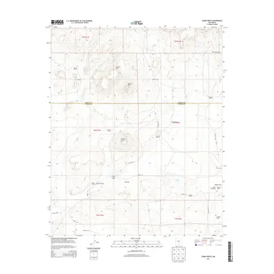
2013 Map of Cerro Prieto
USGS Topo · Published 2013About this map
Flattop Mesa and Hawkins Peak dominate the high-desert landscape of this West-Central New Mexico region, where the border between Cibola and Catron counties cuts through a series of dramatic draws and volcanic formations. The land is defined by a sparse but vital network of water improvements and cattle operations, evidenced by the numerous named landmarks such as Martinez Windmill, Taylor Windmill, and Apodaca Windmill. These features indicate the persistent reliance on groundwater in an arid environment shaped by seasonal drainages like Puertocito Draw and Pascual Draw. Local ranching history is etched into the map through family-named sites including Hubbell Ranch, Montano Ranch, and Browns Ranch. The prominence of the namesake Cerro Prieto volcanic peak serves as a central navigational anchor for this rugged ranching country, where unpaved routes like Hubbell Rd and CO Road AD36 provide the primary connections between isolated homesteads and seasonal water sources like Garcia Lake.
Find a feature on this map
35 named features on this map. Tap any name to fly to it.
Don’t see what you’re looking for? This feature index may not catch every label — zoom into the map to look around manually.
Map Details
Editions of this 2013 Cerro Prieto Map
This is the sole edition of this map. No revisions or reprints were ever made.
Other maps of this area

1954 · Saint Johns
USGS Topo · 1:250,000

1957 · Saint Johns
USGS Topo · 1:250,000

1958 · Saint Johns
USGS Topo · 1:250,000

1962 · Saint Johns
USGS Topo · 1:250,000

1967 · Mariano Springs
USGS Topo · 1:24,000

1967 · Chimney Hill
USGS Topo · 1:24,000
1967 · Techado
USGS Topo · 1:24,000

1972 · Lake Armijo
USGS Topo · 1:24,000

1972 · Fence Lake
USGS Topo · 1:24,000

1972 · Tejana Mesa
USGS Topo · 1:24,000