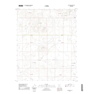
2020 Map of Cerro Prieto
USGS Topo · Published 2020About this map
The high-desert terrain of western New Mexico is defined here by the volcanic prominence of Cerro Prieto and the expansive Flattop Mesa. Straddling the border of Cibola and Catron Counties, this landscape is shaped by a complex network of ephemeral drainages, including Pascual Draw, Frenches Draw, and Lee Draw, which channel seasonal water toward features like Garcia Lake and Green Tank. The mapping shows a sparsely populated area where cattle ranching and land management are the primary drivers of human activity, evident in the network of county roads such as Hubbell Rd and Catron Co Rd A034. Notable landmarks for navigation and local history include Hawkins Peak and the convergence of several minor drainages like Nations Draw and Single Mill Draw in the southeast corner. The presence of named tracks like Waltons Way and Shadow Canyon Ridge Rd reflects a long-standing local presence in this open range country.
Find a feature on this map
32 named features on this map. Tap any name to fly to it.
Don’t see what you’re looking for? This feature index may not catch every label — zoom into the map to look around manually.
Map Details
Editions of this 2020 Cerro Prieto Map
This is the sole edition of this map. No revisions or reprints were ever made.
Other maps of this area

1954 · Saint Johns
USGS Topo · 1:250,000

1957 · Saint Johns
USGS Topo · 1:250,000

1958 · Saint Johns
USGS Topo · 1:250,000

1962 · Saint Johns
USGS Topo · 1:250,000

1967 · Mariano Springs
USGS Topo · 1:24,000

1967 · Chimney Hill
USGS Topo · 1:24,000
1967 · Techado
USGS Topo · 1:24,000

1972 · Lake Armijo
USGS Topo · 1:24,000

1972 · Fence Lake
USGS Topo · 1:24,000

1972 · Tejana Mesa
USGS Topo · 1:24,000