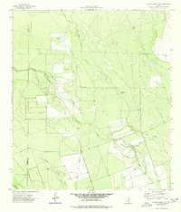
1974 Map of Chacon Creek SE
USGS Topo · Published 1977About this map
The arid ranchlands of the South Texas brush country dominate this landscape, where the confluence of several seasonal drainages defines the local topography. At the heart of the region, Chacon Creek winds through the terrain, joined by tributaries such as Palo Blanco Creek and Spurler Creek. This area, situated along the county line of Maverick Co and Zavala Co, shows a landscape adapted for resource extraction and livestock management in the mid-1970s.
Find a feature on this map
13 named features on this map. Tap any name to fly to it.
Don’t see what you’re looking for? This feature index may not catch every label — zoom into the map to look around manually.
Map Details
Editions of this 1974 Chacon Creek SE Map
This is the sole edition of this map. No revisions or reprints were ever made.
Other maps of this area

1939 · Carrizo Springs
USGS Topo · 1:62,500

1939 · La Pryor
USGS Topo · 1:62,500

1940 · Cometa
USGS Topo · 1:62,500

1940 · Chacon Creek
USGS Topo · 1:62,500

1953 · Crystal City
USGS Topo · 1:250,000

1955 · Crystal City
USGS Topo · 1:250,000

1958 · Eagle Pass
USGS Topo · 1:250,000

1961 · Crystal City
USGS Topo · 1:250,000

1965 · Eagle Pass
USGS Topo · 1:250,000

1968 · Crystal City
USGS Topo · 1:250,000