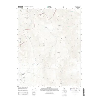
2013 Map of Chacon
USGS Topo · Published 2013About this map
Chacon sits along the Mora River in this high-altitude landscape of Mora County, serving as a focal point for local history and genealogy. The settlement is surrounded by steep terrain where the Sangre de Cristo Mountains and Santa Fe Mountains meet, creating a complex series of drainage basins including Marias Canyon and Quémado Canyon. Much of the northern and western reaches are protected within the Carson National Forest, preserving the rugged character of the Rincon Mountains. Farther east, the small community of Guadalupita and the location of Espinoza mark the transitions between narrow valley floors and the rising slopes. Cultural sites such as the San Antonio Cem provide important links to the area's ancestral families, while the network of mountain roads like Luna Canyon Rd follows the natural contours carved by the West Fork Luna Cr.
Find a feature on this map
25 named features on this map. Tap any name to fly to it.
Don’t see what you’re looking for? This feature index may not catch every label — zoom into the map to look around manually.
Map Details
Editions of this 2013 Chacon Map
This is the sole edition of this map. No revisions or reprints were ever made.
Other maps of this area

1954 · Raton
USGS Topo · 1:250,000

1956 · Tooth Of Time
USGS Topo · 1:62,500

1958 · Raton
USGS Topo · 1:250,000

1965 · Osha Mountain
USGS Topo · 1:24,000

1965 · Chacon
USGS Topo · 1:24,000

1965 · Holman
USGS Topo · 1:24,000

1965 · Shady Brook
USGS Topo · 1:24,000
1965 · Comanche Peak
USGS Topo · 1:24,000
1965 · Cerro Vista
USGS Topo · 1:24,000

1966 · Guadalupita
USGS Topo · 1:24,000