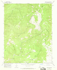
1965 Map of Cerro Vista
USGS Topo · Published 1969About this map
Carson National Forest dominates this mid-1960s landscape, where the Rancho del Rio Grande Grant Boundary marks a historical division in the high country of northern New Mexico. The terrain is defined by prominent peaks such as Cerro Vista and Cerro Olla, with the Rio Grande del Rancho carving a path through the northwest. Small mountain settlements like Chacon and Bilbao sit on the periphery of the deep timber, connected by a network of primitive routes labeled simply as Jeep Trail and Pack Trail. High-elevation water features including Romero Lake and La Cueva Lake are situated near Upper La Junta Campground, indicating the area's role for seasonal recreation and grazing. The presence of the Taos Co Mora Co line cutting across the eastern ridges highlights the administrative geography of this remote territory.
Find a feature on this map
29 named features on this map. Tap any name to fly to it.
Don’t see what you’re looking for? This feature index may not catch every label — zoom into the map to look around manually.
Map Details
Editions of this 1965 Cerro Vista Map
This is the sole edition of this map. No revisions or reprints were ever made.
Other maps of this area

1954 · Raton
USGS Topo · 1:250,000

1958 · Raton
USGS Topo · 1:250,000

1964 · Tres Ritos
USGS Topo · 1:24,000

1964 · Ranchos De Taos
USGS Topo · 1:24,000
1964 · Jicarita Peak
USGS Topo · 1:24,000

1965 · Osha Mountain
USGS Topo · 1:24,000

1965 · Chacon
USGS Topo · 1:24,000

1965 · Holman
USGS Topo · 1:24,000

1965 · Shady Brook
USGS Topo · 1:24,000
1965 · Comanche Peak
USGS Topo · 1:24,000