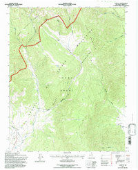
1995 Map of Chacon
USGS Topo · Published 1997About this map
Chacon and Guadalupita sit within the high valley landscape of the Sangre de Cristo Mountains, where the headwaters of the Mora River and Luna Creek descend from the Carson National Forest. This 1995 revision reflects the enduring rural character of northern New Mexico, anchored by the historical boundaries of the Mora Grant. The topography is defined by a series of deep drainages including Lujan Canyon, Williams Canyon, and Silva Canyon, which funnel mountain runoff toward the small valley floor settlements.
Find a feature on this map
22 named features on this map. Tap any name to fly to it.
Don’t see what you’re looking for? This feature index may not catch every label — zoom into the map to look around manually.
Map Details
Editions of this 1995 Chacon Map
This is the sole edition of this map. No revisions or reprints were ever made.
Other maps of this area

1954 · Raton
USGS Topo · 1:250,000

1956 · Tooth Of Time
USGS Topo · 1:62,500

1958 · Raton
USGS Topo · 1:250,000

1965 · Osha Mountain
USGS Topo · 1:24,000

1965 · Chacon
USGS Topo · 1:24,000

1965 · Holman
USGS Topo · 1:24,000

1965 · Shady Brook
USGS Topo · 1:24,000
1965 · Comanche Peak
USGS Topo · 1:24,000
1965 · Cerro Vista
USGS Topo · 1:24,000

1966 · Guadalupita
USGS Topo · 1:24,000