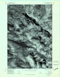
1977 Map of Chain Of Ponds
USGS Topo · Published 1983About this map
Upper Farm sits along the narrow, elongated waters of the Chain of Ponds, marking a rare point of human presence in this high-altitude Maine landscape. This 1977 orthophotograph, rectified from aerial imagery, reveals the stark contrast between the deep, dark water bodies and the densely forested peaks of Snow Mountain and Bag Pond Mountain. The drainage patterns are clearly visible through the timber, with Clearwater Brook feeding the northern reaches while Indian Stream and the North Branch Alder Stream carve through the southern terrain. This perspective is particularly valuable for understanding the natural geography and timberland boundaries before more modern developments, showing Big Island Pond and the surrounding wilderness in a moment of quiet isolation.
Find a feature on this map
8 named features on this map. Tap any name to fly to it.
Don’t see what you’re looking for? This feature index may not catch every label — zoom into the map to look around manually.
Map Details
Editions of this 1977 Chain Of Ponds Map
This is the sole edition of this map. No revisions or reprints were ever made.
Other maps of this area

1928 · Chain Lakes
USGS Topo · 1:48,000

1931 · Cupsuptic
USGS Topo · 1:48,000

1932 · Kennebago Lake
USGS Topo · 1:48,000

1932 · Arnold Pond
USGS Topo · 1:48,000

1932 · Chain Lakes
USGS Topo · 1:62,500

1934 · Cupsuptic
USGS Topo · 1:62,500

1935 · Kennebago Lake
USGS Topo · 1:62,500

1935 · Chain Lakes
USGS Topo · 1:62,500

1935 · Cupsuptic
USGS Topo · 1:62,500

1935 · Arnold Pond
USGS Topo · 1:62,500
Featured Places
- Kibby Township, ME
- Alder Stream Township, ME
- Round Mountain, Alder Stream Township
- Seven Ponds Township, ME
- Chain of Ponds Township, ME