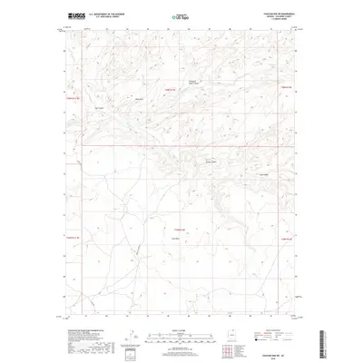
2018 Map of Chaiyahi Rim SW
USGS Topo · Published 2018About this map
Gray Mesa dominates the southern portion of this high-desert landscape in Coconino County, rising above a network of deep drainages and geological landmarks. The terrain is defined by dramatic erosion, featuring the natural formation of Mikes Arch and the winding paths of Navajo Canyon, Jayii Canyon, and Long Canyon. Intermittent waterways including Chaiyahi Cr and Navajo Cr thread through the sandstone, while Trampled Water Canyon suggests the historic importance of seasonal water sources in this arid environment. Transportation across this section of the Navajo Nation is limited to remote tracks such as Navajo Canyon Rd and Rte 6330, reflecting the isolation of this high-altitude rim country in the early twenty-first century. The map provides a detailed view of the Public Land Survey System divisions, from T40N R13E down through T39N R14E.
Find a feature on this map
16 named features on this map. Tap any name to fly to it.
Don’t see what you’re looking for? This feature index may not catch every label — zoom into the map to look around manually.
Map Details
Editions of this 2018 Chaiyahi Rim SW Map
This is the sole edition of this map. No revisions or reprints were ever made.
Other maps of this area

1883 · Marsh Pass
USGS Topo · 1:250,000

1886 · Echo Cliffs
USGS Topo · 1:250,000

1891 · Echo Cliffs
USGS Topo · 1:250,000

1892 · Marsh Pass
USGS Topo · 1:250,000

1954 · Navajo Creek
USGS Topo · 1:62,500

1956 · Marble Canyon
USGS Topo · 1:250,000

1959 · Marble Canyon
USGS Topo · 1:250,000

1961 · Marble Canyon
USGS Topo · 1:250,000
1970 · Chaiyahi Rim SW
USGS Topo · 1:24,000
1970 · Two Red Mesas
USGS Topo · 1:24,000