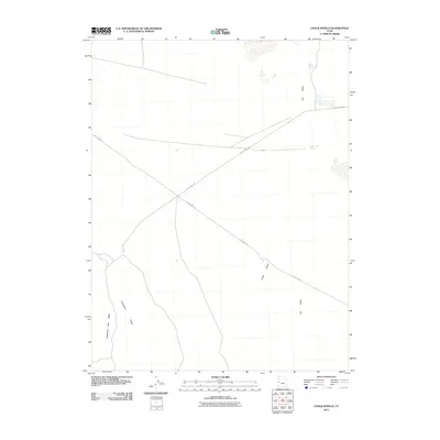
2011 Map of Chalk Knolls
USGS Topo · Published 2011About this map
Chalk Knolls and the surrounding high desert terrain define this corner of Millard County, where water sources are the primary landmarks of the landscape. The map highlights a series of essential desert seeps, including Willow Spring, Tule Spring, and South Tule Spring, which historically supported movement through this arid region. The topography is dominated by the Tule Valley and the eastern edge of the Confusion Range, with the narrow Cattlemens Little Valley tucked between the ridges. Human passage is marked by long-standing transit corridors such as the Old 6 and 50, which cuts a diagonal path across the quadrangle. Other routes, including Tule Spring Rd and Death Canyon Rd, connect these scattered water points, reflecting the functional infrastructure of Utah's remote western valleys in the early 21st century.
Find a feature on this map
10 named features on this map. Tap any name to fly to it.
Don’t see what you’re looking for? This feature index may not catch every label — zoom into the map to look around manually.
Map Details
Editions of this 2011 Chalk Knolls Map
This is the sole edition of this map. No revisions or reprints were ever made.
Other maps of this area

1908 · Fish Springs
USGS Topo · 1:250,000

1910 · Fish Springs
USGS Topo · 1:250,000

1953 · Delta
USGS Topo · 1:250,000

1958 · Delta
USGS Topo · 1:250,000

1959 · Cowboy Pass
USGS Topo · 1:62,500

1960 · Notch Peak
USGS Topo · 1:62,500

1960 · Conger Mountain
USGS Topo · 1:62,500

1962 · Delta
USGS Topo · 1:250,000

1972 · Swasey Peak SW
USGS Topo · 1:24,000
1972 · Swasey Peak NW
USGS Topo · 1:24,000