
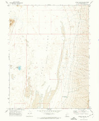
1991 Map of Chalk Knolls
USGS Topo · Published 1991About this map
The Chalk Knolls rise sharply from the floor of the Tule Valley, a desert depression in western Millard County. This 1991 provisional map documents a landscape defined by its scarce water sources and dramatic topographic shifts between the basin floor and the eastern edge of the Confusion Range. The presence of Willow Spring, Tule Spring, and South Tule Spring highlights the critical points of hydration in an otherwise arid environment, connected primarily by the Tule Spring Road. To the southwest, the terrain transitions into Little Valley and an area labeled Cattlemens, suggesting the historical use of these basins for seasonal grazing. The map provides a meticulous record of benchmark elevations and section lines across these desert flats, useful for understanding the grazing and water-rights geography of this part of the Great Basin.
Find a feature on this map
11 named features on this map. Tap any name to fly to it.
Don’t see what you’re looking for? This feature index may not catch every label — zoom into the map to look around manually.
Map Details
Editions of this 1991 Chalk Knolls Map
This is the sole edition of this map. No revisions or reprints were ever made.
Other maps of this area

1908 · Fish Springs
USGS Topo · 1:250,000

1910 · Fish Springs
USGS Topo · 1:250,000

1953 · Delta
USGS Topo · 1:250,000

1958 · Delta
USGS Topo · 1:250,000

1959 · Cowboy Pass
USGS Topo · 1:62,500

1960 · Notch Peak
USGS Topo · 1:62,500

1960 · Conger Mountain
USGS Topo · 1:62,500

1962 · Delta
USGS Topo · 1:250,000

1972 · Swasey Peak SW
USGS Topo · 1:24,000
1972 · Swasey Peak NW
USGS Topo · 1:24,000