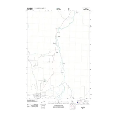
2011 Map of Challis
USGS Topo · Published 2011About this map
Challis serves as the focal point of this Custer County landscape, situated at the junction of several vital waterways and canyons. The Salmon River flows prominently through the central valley, flanked by the braided channels of Hannah Slough and fed by Garden Creek and Challis Creek near the town center. To the north, the terrain transitions into a series of named gulches and high points, including McNabbs Point and Round Valley, illustrating the complex drainage patterns of the region. This 2011 survey documents the layout of local infrastructure such as the Challis Airport and the Penal Gulch Access Area, alongside rural routes like Darling Creek Rd that provide access to the surrounding heights. The map records a modern settlement pattern deeply influenced by the original water sources and natural corridors of the Idaho interior.
Find a feature on this map
18 named features on this map. Tap any name to fly to it.
Don’t see what you’re looking for? This feature index may not catch every label — zoom into the map to look around manually.
Map Details
Editions of this 2011 Challis Map
This is the sole edition of this map. No revisions or reprints were ever made.
Other maps of this area

1929 · Bayhorse
USGS Topo · 1:125,000

1956 · Challis
USGS Topo · 1:62,500

1956 · Twin Peaks
USGS Topo · 1:62,500

1957 · Challis
USGS Topo · 1:250,000

1960 · Challis
USGS Topo · 1:250,000

1963 · Challis
USGS Topo · 1:250,000

1963 · Bayhorse
USGS Topo · 1:24,000
1963 · Little Antelope Flat
USGS Topo · 1:24,000

1963 · Clayton
USGS Topo · 1:62,500

1963 · Lone Pine Peak
USGS Topo · 1:62,500