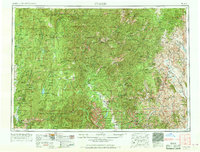
1957 Map of Challis
USGS Topo · Published 1969About this map
The Salmon River and its numerous forks define this expansive mid-century survey of central Idaho, carving through the massive Salmon River Mountains and the jagged Sawtooth Range. The landscape is dominated by a vast network of protected lands, including the Challis National Forest and Boise National Forest. Human activity is concentrated along the river valleys and high-elevation mining districts. Early settlements and mining camps like Bonanza, Custer, and Clayton are documented alongside active extraction sites such as the Yellowjacket Mine and Ramshorn Mine. This era reflects a transition where traditional resource extraction coexisted with increasing federal management, evidenced by the numerous administrative sites like the Cape Horn Guard Station and Seafoam Ranger Station. Transportation routes like 93 follow the natural paths of the Pahsimeroi River and Salmon, connecting remote outposts like Patterson and May to the regional hub at Challis.
Find a feature on this map
94 named features on this map. Tap any name to fly to it.
Don’t see what you’re looking for? This feature index may not catch every label — zoom into the map to look around manually.
Map Details
Editions of this 1957 Challis Map
3 editions found

Other maps of this area

1891 · Bear Valley
USGS Topo · 1:125,000

1892 · Boise
USGS Topo · 1:125,000

1893 · Bear Valley
USGS Topo · 1:125,000

1894 · Squaw Creek
USGS Topo · 1:125,000

1894 · Idaho Basin
USGS Topo · 1:125,000

1894 · Rocky Bar
USGS Topo · 1:125,000

1895 · Hailey
USGS Topo · 1:125,000

1897 · Boise
USGS Topo · 1:125,000

1897 · Hailey
USGS Topo · 1:125,000

1900 · Sawtooth
USGS Topo · 1:125,000