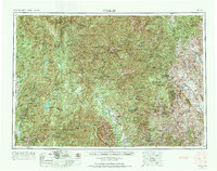
1957 Map of Challis
USGS Topo · Published 1973About this map
The Salmon River and its multiple forks carve through this expansive section of central Idaho, anchoring a landscape defined by isolated mining camps and high-altitude settlements. In the mid-1950s, the region's mineral economy is visible through sites like the Blackbird Mine near Cobalt and the Sunbeam Mine along the Yankee Fork. These operations, alongside remote outposts such as Stibnite and Yellow Pine, highlight the enduring importance of extraction in the Salmon River Mountains.
Find a feature on this map
102 named features on this map. Tap any name to fly to it.
Don’t see what you’re looking for? This feature index may not catch every label — zoom into the map to look around manually.
Map Details
Editions of this 1957 Challis Map
3 editions found

Other maps of this area

1891 · Bear Valley
USGS Topo · 1:125,000

1892 · Boise
USGS Topo · 1:125,000

1893 · Bear Valley
USGS Topo · 1:125,000

1894 · Squaw Creek
USGS Topo · 1:125,000

1894 · Idaho Basin
USGS Topo · 1:125,000

1894 · Rocky Bar
USGS Topo · 1:125,000

1895 · Hailey
USGS Topo · 1:125,000

1897 · Boise
USGS Topo · 1:125,000

1897 · Hailey
USGS Topo · 1:125,000

1900 · Sawtooth
USGS Topo · 1:125,000