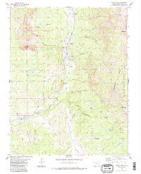
1984 Map of Chama Peak
USGS Topo · Published 1984About this map
The Tierra Amarilla Grant Boundary cuts through the high-elevation terrain of this 1984 survey, marking a legacy of Spanish and Mexican land grants in the San Juan Mountains. The landscape is defined by the headwaters of the Navajo River and the Rio Chamita, separated by the high ridges of the Continental Divide. Industrial footprints are surprisingly present in this remote high country, most notably the Oil Field and Gramps settlement near the riverbanks. Water management infrastructure, critical for the region's downstream agriculture, is highlighted by the Oso Diversion Dam and the Oso Tunnel. High-altitude lakes like Dolomite Lake and Native Lake are tucked into the drainages below towering summits such as Chama Peak and Banded Peak. A network of travel routes including the Skeeter Park Trail and various Jeep Trails provide the primary access to these meadows and alpine slopes.
Find a feature on this map
49 named features on this map. Tap any name to fly to it.
Don’t see what you’re looking for? This feature index may not catch every label — zoom into the map to look around manually.
Map Details
Editions of this 1984 Chama Peak Map
2 editions found
Other maps of this area

1913 · Summitville
USGS Topo · 1:125,000

1915 · Summitville
USGS Topo · 1:125,000

1945 · Durango
USGS Topo · 1:250,000

1953 · Durango
USGS Topo · 1:250,000

1954 · Durango
USGS Topo · 1:250,000

1954 · Aztec
USGS Topo · 1:250,000

1955 · Chama
USGS Topo · 1:62,500

1955 · Lumberton
USGS Topo · 1:62,500

1957 · Chromo
USGS Topo · 1:62,500

1957 · Chama Peak
USGS Topo · 1:62,500