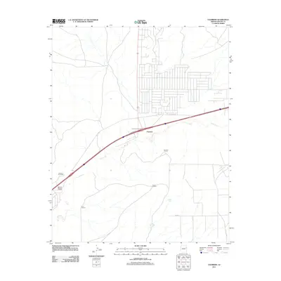
2011 Map of Chambers
USGS Topo · Published 2011About this map
The Puerco River corridor defines the landscape of this high-desert region in Apache County, where modern transportation infrastructure meets traditional land use. The settlement of Chambers sits at a critical junction, marked by the Chambers Interchange and the adjacent Frontage Rd. This 2011 survey illustrates how water remains the primary driver of development in this arid environment, evidenced by a network of isolated water sources including Chambers Windmill, Peplote Windmill, River Windmill, and Squaw Springs. For those researching local family history, the McCarroll Memorial Cemetery stands near the McCarroll Interchange along the river's path, providing a specific point of reference for ancestral ties to this portion of the Fort Defiance Agency area.
Find a feature on this map
14 named features on this map. Tap any name to fly to it.
Don’t see what you’re looking for? This feature index may not catch every label — zoom into the map to look around manually.
Map Details
Editions of this 2011 Chambers Map
This is the sole edition of this map. No revisions or reprints were ever made.
Other maps of this area

1886 · Fort Defiance
USGS Topo · 1:250,000

1892 · Fort Defiance
USGS Topo · 1:250,000

1954 · Gallup
USGS Topo · 1:250,000

1958 · Gallup
USGS Topo · 1:250,000

1959 · Gallup
USGS Topo · 1:250,000

1962 · Gallup
USGS Topo · 1:250,000

1967 · Gallup
USGS Topo · 1:250,000

1971 · Burntwater Wash
USGS Topo · 1:24,000
1971 · Sanders
USGS Topo · 1:24,000
1971 · Chambers
USGS Topo · 1:24,000