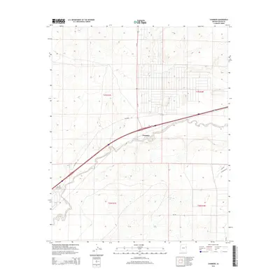
2014 Map of Chambers
USGS Topo · Published 2014About this map
Chambers serves as the primary hub of activity in this high-desert landscape, situated where the Puerco River carves its way through the terrain. The presence of the McCarrell Memorial Cem and McCarroll Rd suggests a deep-rooted history for the McCarrell family in this portion of Apache County. The map details a transition from the structured transportation corridor of Us-191 to more remote tracks like Main Rd and Sand Springs Dr. Water is a scarce and vital resource here, marked by isolated points such as Squaw Springs and Hidden Tank. These features, along with the surrounding cattle tanks and township grids, provide an look into the land management and sparse settlement patterns of this region near the Fort Defiance Agency.
Find a feature on this map
16 named features on this map. Tap any name to fly to it.
Don’t see what you’re looking for? This feature index may not catch every label — zoom into the map to look around manually.
Map Details
Editions of this 2014 Chambers Map
This is the sole edition of this map. No revisions or reprints were ever made.
Other maps of this area

1886 · Fort Defiance
USGS Topo · 1:250,000

1892 · Fort Defiance
USGS Topo · 1:250,000

1954 · Gallup
USGS Topo · 1:250,000

1958 · Gallup
USGS Topo · 1:250,000

1959 · Gallup
USGS Topo · 1:250,000

1962 · Gallup
USGS Topo · 1:250,000

1967 · Gallup
USGS Topo · 1:250,000

1971 · Burntwater Wash
USGS Topo · 1:24,000
1971 · Sanders
USGS Topo · 1:24,000
1971 · Chambers
USGS Topo · 1:24,000