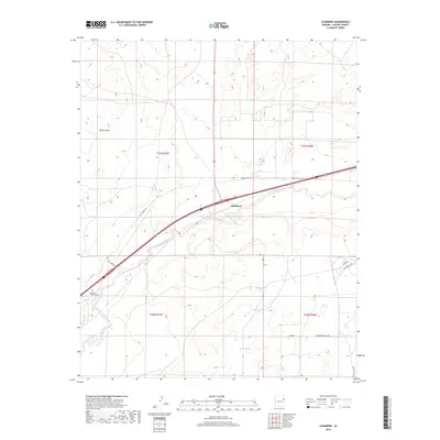
2018 Map of Chambers
USGS Topo · Published 2018About this map
Chambers sits as a primary transit point in this portion of Apache County, where several local routes and service roads converge along the high desert landscape. The Puerco River carves a path through the center of the sheet, providing a vital drainage corridor for a terrain characterized by prominent landforms like Padres Mesa. In the southwestern corner, the McCarrell Memorial Cem serves as a significant genealogical landmark for those tracing local family histories in this part of the Fort Defiance Agency area. The map illustrates a rural infrastructure of named roads, including Mc Carroll Rd and Sand Springs Dr, alongside water features like Squaw Springs and Hidden Tank. This layout reflects the area's ongoing importance as a junction for both residents and those traveling the high-altitude routes through eastern Arizona.
Find a feature on this map
17 named features on this map. Tap any name to fly to it.
Don’t see what you’re looking for? This feature index may not catch every label — zoom into the map to look around manually.
Map Details
Editions of this 2018 Chambers Map
This is the sole edition of this map. No revisions or reprints were ever made.
Other maps of this area

1886 · Fort Defiance
USGS Topo · 1:250,000

1892 · Fort Defiance
USGS Topo · 1:250,000

1954 · Gallup
USGS Topo · 1:250,000

1958 · Gallup
USGS Topo · 1:250,000

1959 · Gallup
USGS Topo · 1:250,000

1962 · Gallup
USGS Topo · 1:250,000

1967 · Gallup
USGS Topo · 1:250,000

1971 · Burntwater Wash
USGS Topo · 1:24,000
1971 · Sanders
USGS Topo · 1:24,000
1971 · Chambers
USGS Topo · 1:24,000