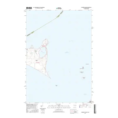
2016 Map of Chambers Island
USGS Topo · Published 2016About this map
Chambers Island is the central focus of this 2016 survey, sitting within the waters of Green Bay and Lake Michigan. The island's geography is defined by two significant interior bodies of water, Mackaysee Lake and Mud Lake, and the prominent northwest projection of Sand Point. This modern topographic study shows the island's small infrastructure network, including Island Dr and Base Line Rd, which provide access to the Chambers Island Airport. To the southeast, the map details the archipelago of the Strawberry Islands, which includes Jack Island, Pirate Island, Little Strawberry Island, and Adventure Island. The underwater topography is also noted, particularly Hanover Shoal and the Strawberry Channel, providing a clear picture of the maritime hazards and passages surrounding these islands in Door County.
Find a feature on this map
20 named features on this map. Tap any name to fly to it.
Don’t see what you’re looking for? This feature index may not catch every label — zoom into the map to look around manually.
Map Details
Editions of this 2016 Chambers Island Map
This is the sole edition of this map. No revisions or reprints were ever made.
Other maps of this area

1954 · Escanaba
USGS Topo · 1:250,000

1957 · Escanaba
USGS Topo · 1:250,000

1958 · Escanaba
USGS Topo · 1:250,000

1960 · Sister Bay
USGS Topo · 1:62,500

1960 · Ellison Bay
USGS Topo · 1:62,500

1961 · Chambers Island
USGS Topo · 1:62,500

1963 · Cedar River
USGS Topo · 1:62,500

1981 · Marinette
USGS Topo · 1:100,000
1982 · Green Island
USGS Topo · 1:24,000
1982 · Baileys Harbor West
USGS Topo · 1:24,000